
Bay Cats, Hornbills, Pangolins and the Data Behind Community Forest Management
The First Season Results from Gunung Naning Bioacoustic and Camera Trap Surveys and the Four Ways Communities Are Using This Data
by Ziva Justinek, Rikardus Samabat
Executive Summary
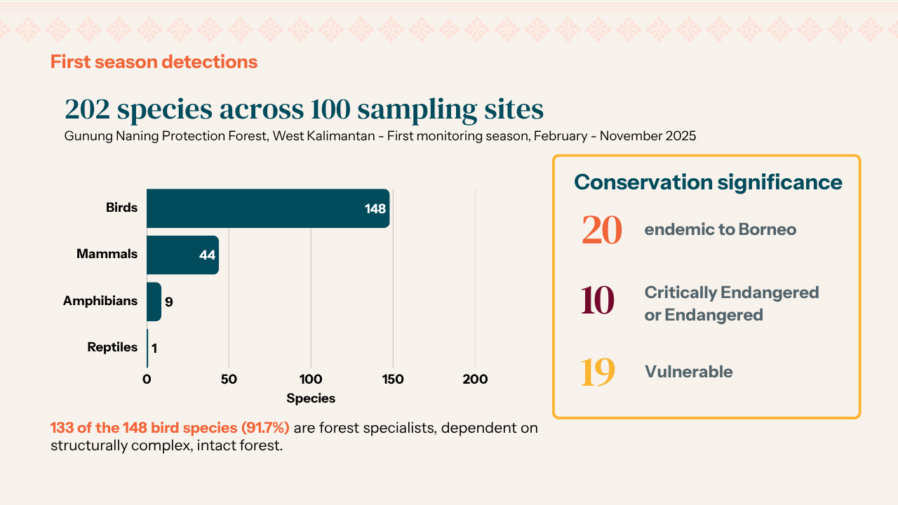
Between February and November 2025, Planet Indonesia and WildMon ran a combined bioacoustic and camera trap survey across 100 sites in the Gunung Naning Protection Forest, West Kalimantan. The first season detected 202 species in total, including 20 species endemic to Borneo and 10 Endangered or Critically Endangered species.
Several findings have biogeographical significance. The Hose's palm civet, an endemic species to Borneo and one of the world’s rarest carnivores, was recorded at 18 sites in what is likely the first documented occurrence in West Kalimantan. The Bornean bay cat, among the least-studied wild felids, was detected at two sites. The Bornean white-bearded gibbon was recorded at 58 sites, indicating broad habitat connectivity and low disturbance. Both Critically Endangered species, the Sunda pangolin and helmeted hornbill, were distributed across the monitoring area rather than confined to isolated patches, pointing to landscape-level protection. 91.7% of bird species recorded were forest specialists, a strong indicator of the habitat’s integrity at scale.
The data is being treated far beyond a research output; it is first and foremost used by communities in their management systems. The data feeds directly into patrol planning by community patrol teams, into Social Forestry permit processes where a documented species inventory constitutes substantive evidence, and into community-facing dashboards currently being built, which Community Governance Bodies will utilize to make informed natural resource management decisions.
Across the 725,916-hectare landscape, this data becomes a foundation for a new coordinated planning process that will link together over 20 separate community and indigenous forests into a single, connected conservation network, the largest of its kind managed by indigenous communities anywhere in Borneo.
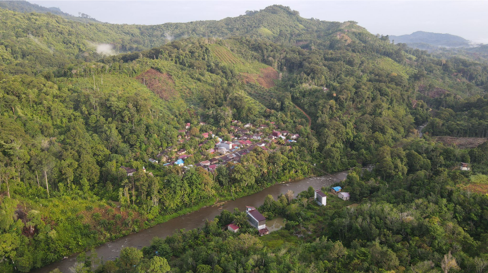
Borneo’s ancient rainforests rank among the top three largest and most biodiverse tropical rainforests on Earth, hosting more than two-thirds of the world’s terrestrial biodiversity, together with the Amazon Rainforest and the Congo Basin.
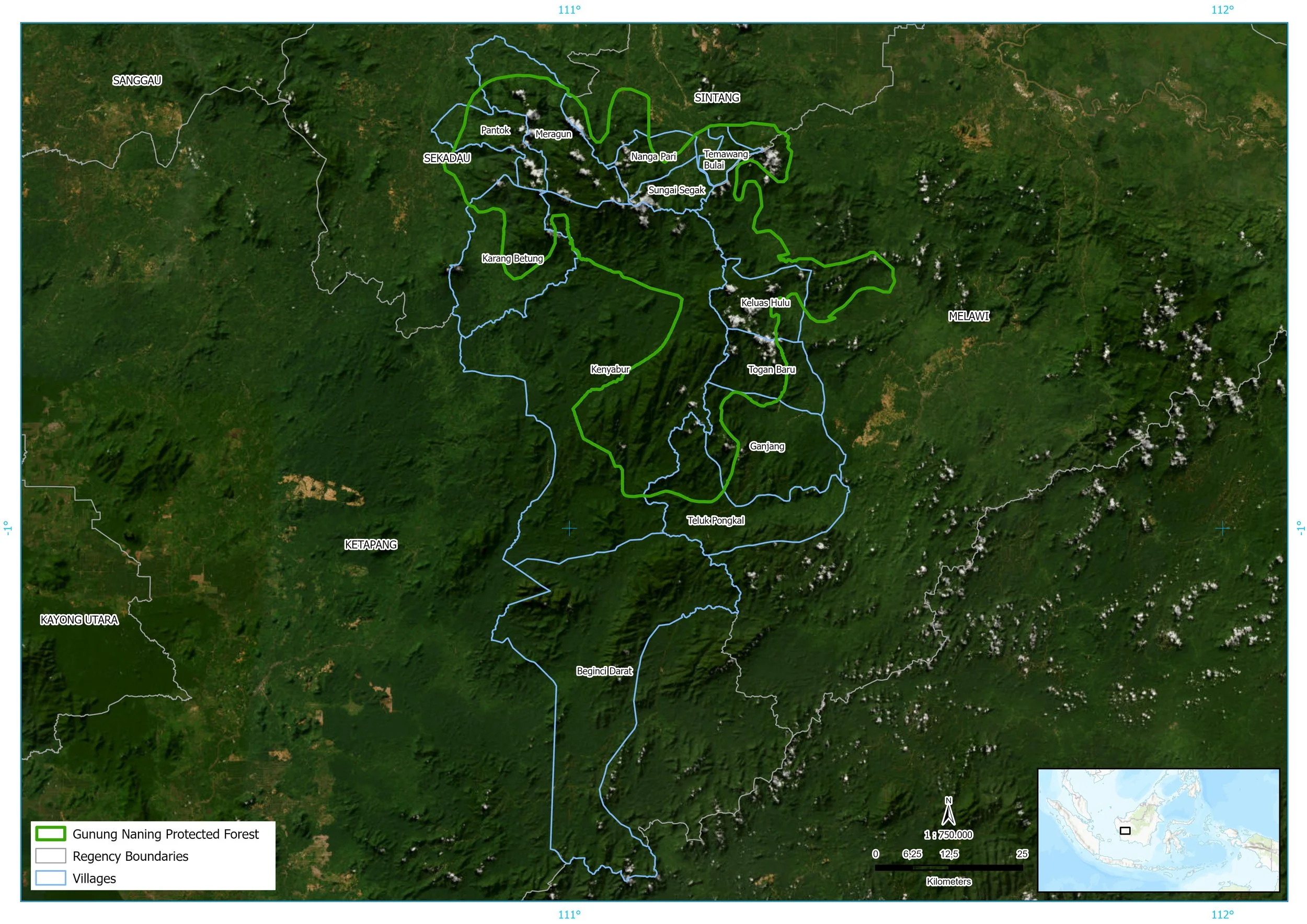
The Gunung Naning forested landscape covers 725,916 hectares across four regencies (Sekadau, Sintang, Ketapang, and Melawi) in West Kalimantan, Indonesian Borneo. At its center sits the Gunung Naning Protection Forest, a 229,000-hectare block of lowland and submontane tropical forest that serves as the ecological core of the wider landscape. This landscape forms a part of the larger Arabella-Schwanner Forest Complex and is also a part of the largest continuous forest across Borneo, known as the Heart of Borneo. This area is also home to Dayak communities with long-standing customary ties to their forest territories.
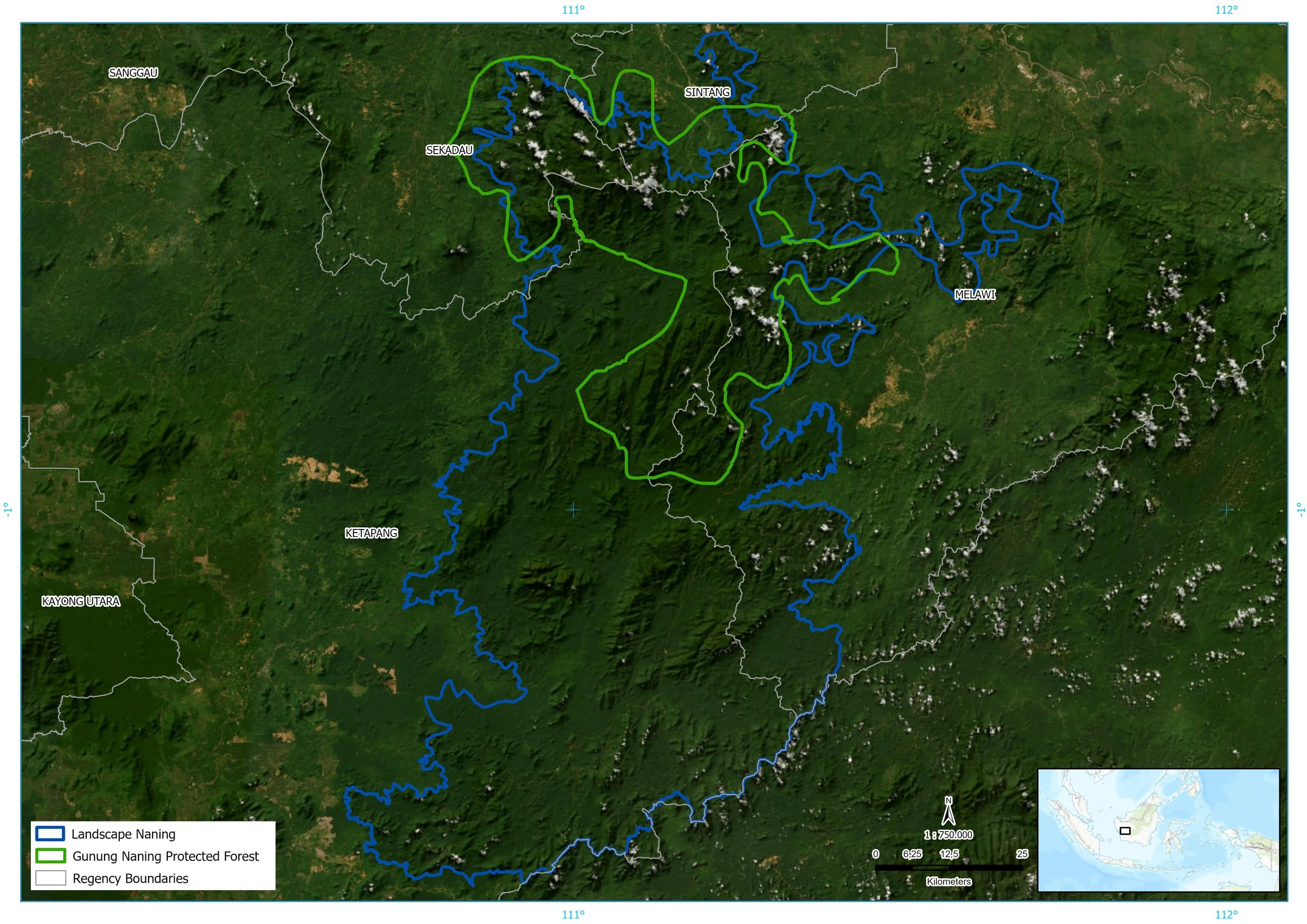
The forested area of the Gunung Naning landscape (blue line border) with the Gunung Naning Protection Forest (green line border)
In our first post on this project, we described the setup: how Planet Indonesia and WildMon co-designed a bioacoustic and camera trap monitoring system for the northern section of Gunung Naning Protection Forest, how Dayak community members used their knowledge of wildlife signs and forest trails to optimize wildlife detection, and what the first deployment in February 2025 looked like on the ground.
While the second season of surveys is underway, the first season’s results are nothing short of inspiring.
Planet Indonesia has been partnering with the communities across the northern two regencies of Sintang and Sekadau since 2020, supporting community-led forest management through Community Governance Bodies and their SMART patrols. Utilizing their intricate knowledge of animal presence, signs of key species and complex terrain, community members meticulously selected locations across 100 grids, where camera traps and sound recorders were deployed.
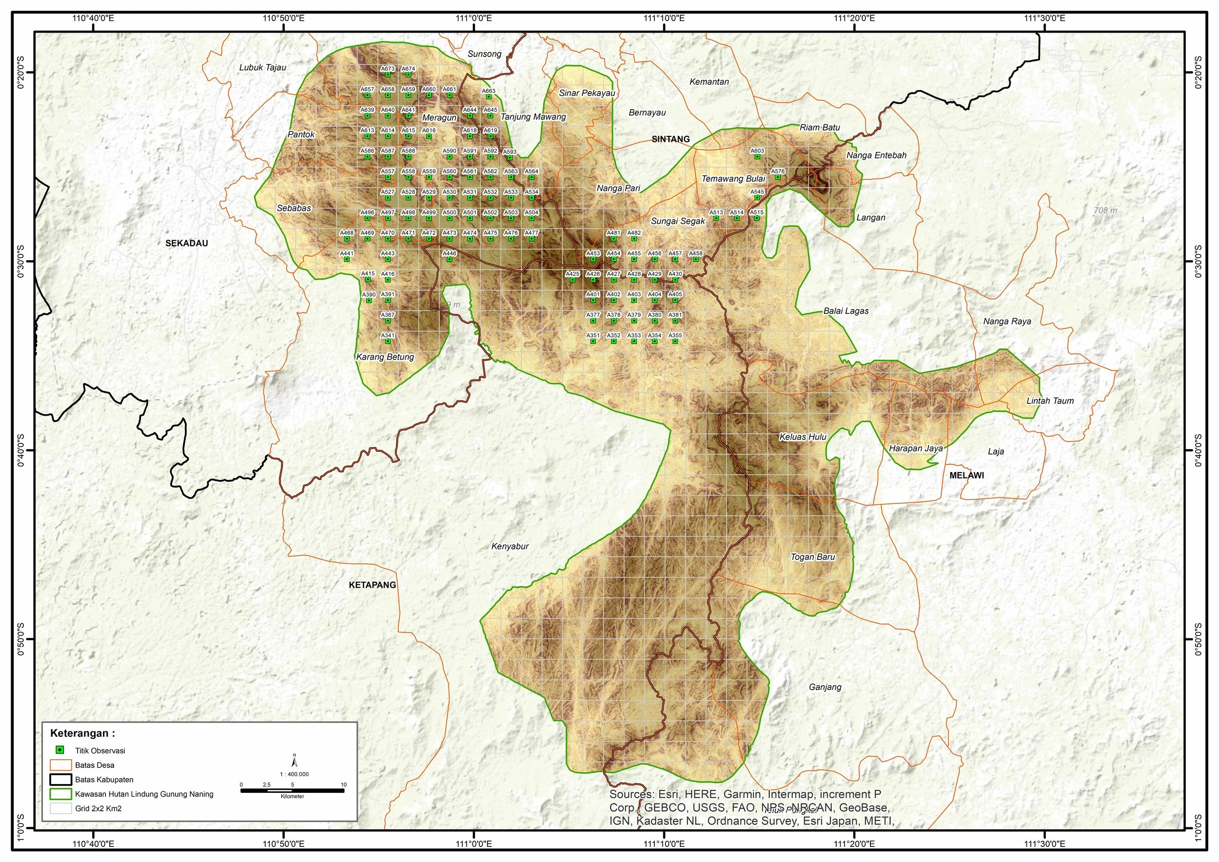
Selected grids in the north section of Gunung Naning Protection Forest.
Research design and analyses
Each site had a recording device - the SongMeter Micro 2 - capturing a 60-second clip every five minutes for a two-week duration, and a motion-triggered Bushnell camera for six weeks. In total, 800,000 sound recordings and nearly 100,000 photos were produced, a sheer volume of data our team could never have reviewed manually in any reasonable timeframe. This is where new technologies made the difference. WildMon used AI foundation models trained to recognize animal sounds (BirdNET and Perch) to sort through the audio files. As quite a number of species are endemic to Borneo and not always recognized in global models, the team built custom reference templates from regional reference calls and local taxonomic knowledge to fill the gaps. In doing so, we realized that 56 of the 164 species identified acoustically had no representation in existing foundation models, nor did 14 of the 63 species captured by cameras, reminding us again just how distinct and important the Gunung Naning landscape is. WildMon is now using these acoustic recordings to train a region-specific convolutional neural network (CNN) built specifically for the Gunung Naning landscape, which will improve detection performance for the second monitoring season. The 14 camera-detected species absent from the current Wildlife Insights model will be incorporated into its training data, too, meaning that over time the tools get sharper so conservation decisions can keep pace with what's happening on the ground.
The birds show the value of Gunung Naning
The 202 species detected and their composition show a well-preserved area. Of the bird species recorded, 133 (91.7%) were classified as forest specialists - species dependent on structurally complex, intact forest habitat. This is particularly meaningful in an ecological sense: forest specialists, especially understory species, are among the first to disappear as forests degrade. Their high representation across 100 sites indicates broad habitat quality rather than localized patches of intact cover.
Several other findings are notable at a biogeographical level
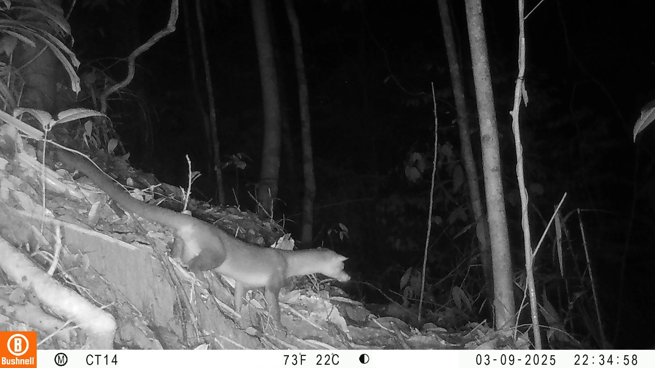
Night-active Hose’s palm civet captured by a camera trap.
Hose's palm civet (Diplogale hosei), considered one of the rarest and least-documented carnivores globally, was recorded at 18 locations with 125 individual camera trap detections. The species is known primarily from northern Sarawak and Sabah; prior to this survey, only one documented record existed from Indonesia (Central Kalimantan). The Gunung Naning detections are likely the first for West Kalimantan and substantially expand the known documentation of this species within Indonesia.
The Bornean bay cat (Catopuma badia), the only cat endemic to Borneo and one of the least-studied wild felids globally, was captured at two camera trap sites. Camera trap studies in areas classified as moderately to highly suitable habitat have frequently failed to detect this species; its occurrence here adds to the limited documentation of its range within Kalimantan.
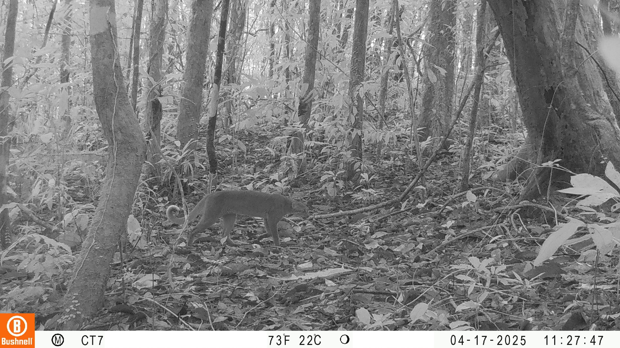
One of the most elusive species - Bornean bay cat.
From the field
Morning mist still filled the spaces between the trees as the wildlife monitoring team prepared to leave the small camp on the edge of the river at the foot of Berangin Hill. Amidst the cold breath and the hungry leeches waiting on the trail, the sounds of the gibbons and the hornbills echoed each other like a natural orchestra welcoming a new day.
Indra, the team leader, stared intently at the map that looked damp with dew. "Okay, today we're going deeper," he said in a calm and firm tone. "Camera traps and sound recorders should be installed in the southern hills, in the hope of collecting data and discovering rare species."
The other three members — Juki, Vinsen and Pak Kepera, the team-designated guide from Sungai Segak village — nodded in unison. They knew that today's journey would be no ordinary one and would certainly be very tiring. One of their goals was to capture footage of the Kucing Merah Kalimantan (Bornean bay cat), the rarest cat, almost impossible for humans to encounter directly.
. . .
Two months later the team set off again to pick up the wildlife monitoring equipment. Upon arriving at the destination, with pounding hearts and a sense of curiosity, they immediately checked the camera trap footage. It took several minutes before the screen showed the image of the Bornean bay cat. No one made a sound, only stunned breaths and sparkling eyes. "This is what we have been waiting for," said Indra, with a voice that trembled between amazement and emotion. "Finally we managed to prove it," added Juki with a broad smile.
The Bornean white-bearded gibbon (Hylobates albibarbis) was detected at 58 of the 100 sampling sites. Gibbons are indicators of habitat quality: they are highly territorial, depend on primary forest, and are absent from areas with sustained hunting pressure. The frequency of detection across the sampling grid is a reasonably strong signal of habitat connectivity and low disturbance across the broader study area.
Two Critically Endangered species - the Sunda pangolin (Manis javanica, detected at 18 camera sites) and the helmeted hornbill (Rhinoplax vigil, detected at 31 acoustic sites) - were present across a significant portion of the monitoring area. Both are targets of active illegal trade and require intact forest with limited human pressure to persist. Their distribution across the sampling grid, rather than concentration at a few sites, suggests landscape-level rather than isolated patch-level protection.
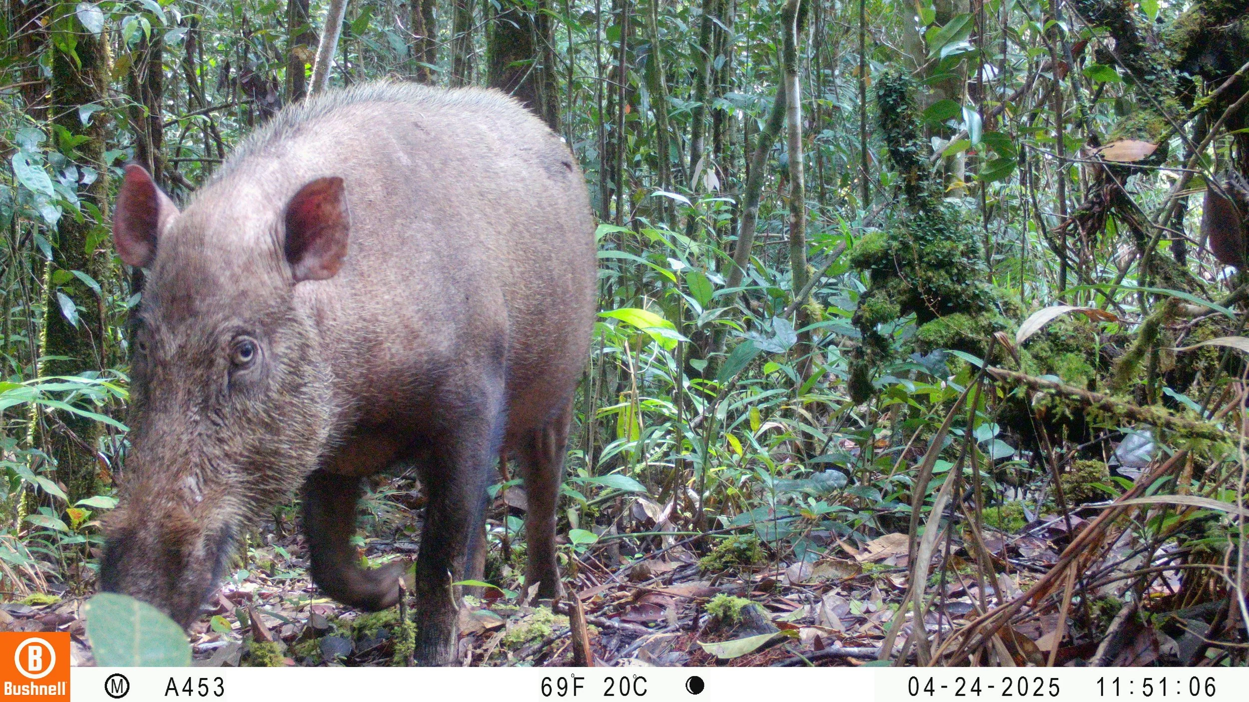
The only native and endemic wild boar species in Borneo - the Bornean bearded pig.
Another find worth flagging from the camera trap data: the Bornean bearded pig (Sus barbatus) was detected in only 14 sites. This species is heavily hunted across Borneo for its prized meat, but due to their reproductive strategy, they only suffered a serious hit to the population in 2021, when the African Swine Fever spread across Borneo and effectively wiped out bearded pigs. The Dayak communities in the landscape reported no sightings for years up until 2024, and the collected data confirms their observations.
Where this data comes to life
The Gunung Naning Protection Forest with its 229,000 hectares at the center of this monitoring effort is not an isolated study site. It sits at the core of the Gunung Naning landscape, which stretches further into Central Kalimantan. Planet Indonesia currently partners with 15 Community Governance Bodies (CGBs) across 12 villages in this landscape.
Planet Indonesia’s partnering villages (blue line borders) across the Gunung Naning landscape.
There are four ways the communities are using this data:
Planning SMART patrols
Community patrol teams use SMART patrol data to track wildlife encounters and signs of illegal activity. The bioacoustic and camera trap survey adds a structured, independent layer to that picture. The distribution of threatened species, particularly the Sunda pangolin, given active trade pressure in West Kalimantan, gives patrol teams a starting point for prioritising where patrol effort has the greatest conservation return. Helmeted hornbill detections, similarly, carry direct relevance to anti-poaching planning given the known trafficking of casques into the collector market.
Social Forestry applications
For communities working to secure land tenure through Social Forestry permit processes or customary territory recognition, a documented species inventory is substantive evidence required among the mountain of legal and management documents needed for the application. The independently generated record of 20 Borneo-endemic species and a range of IUCN Red Listed species across the monitoring area has the potential to strengthen cases made to government counterparts.
Community dashboards as a pathway to better data justice
There is also a broader data justice question that this monitoring work has surfaced. A study led by our Social Sciences Director, Paul Thung et al. (2026) specifically assessed how fairly communities in PI's program areas perceived their relationship to conservation data, covering six dimensions including who collects it, who controls it, who can access it, and what consequences flow from it. Data access and data control were rated the least fair dimensions by both NGO staff and community respondents. Communities had a largely passive relationship to information about their own forests: data flowed up and out, not back to the people who live and make decisions in those landscapes.
The community dashboards that are being built as part of this project are a direct response to that finding. Each CGB will have access to a non-technical interface showing the species data from their area in the local language, designed for use in community governance meetings rather than external reporting.
Landscape-level coordinated forest management
At the landscape scale, the monitoring work feeds into a longer-term vision of coordinated governance. The aim is to use the biodiversity data, SMART patrol data, and community land-use information as inputs into Marxan spatial planning: a systematic process for identifying the configuration of core no-take zones, buffer areas, and forest corridors across the landscape. This spatial plan would form the ecological basis for a landscape-level Indigenous governance arrangement currently envisioned as the Lembaga Adat Gunung Naning (LAGN) - an indigenous governance institution that would coordinate across the individual community territories and serve as the formal counterpart to government and conservation agencies at landscape scale. This would likely become one of the largest indigenous-led conservation landscapes in Borneo.
The first season of monitoring data is one input into that trajectory. The second season deployment in the field has just finished, and the aim is to expand the survey coverage to the southern portion of Gunung Naning later this year.
The Gunung Naning bioacoustic and camera trap monitoring project is a collaboration between Planet Indonesia and WildMon, with support from the Department of Environment, the Agency for the Conservation of Natural Resources, and local Forest Management Units. This work is part of Planet Indonesia's broader effort to support community-led forest governance across the HLGN landscape in West Kalimantan.
If you have any questions, please reach out via admin@planetindonesia.org. Sign up for our newsletter and follow us on our social media Facebook here, Instagram here, and LinkedIn here to get timely updates on our activities, an insider’s look into the lives of front-line conservationists, and ongoing programs.